El nino phenomenon — Stock Vector

El nino phenomenon — Vector

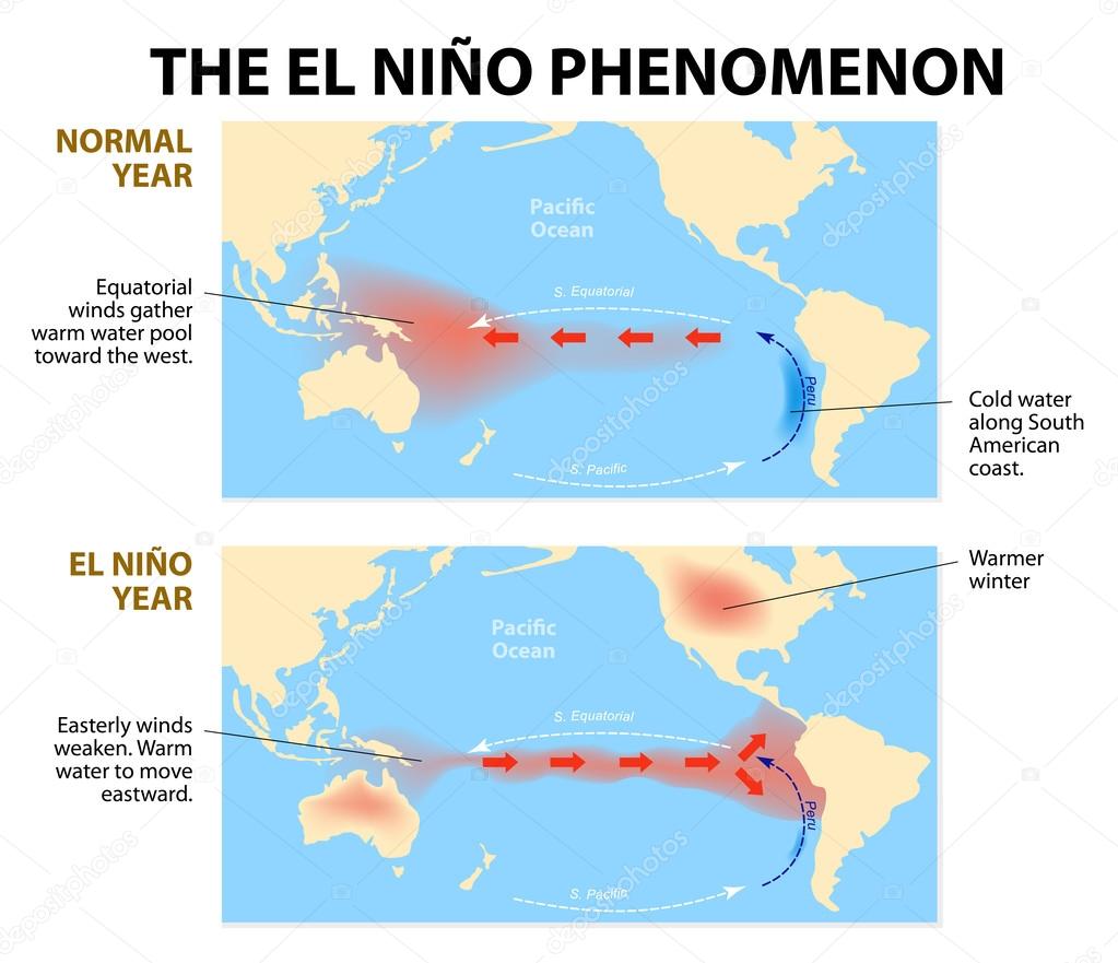
Diagram shows the El Nino phenomenon. El Niño is a disruption of the ocean and atmosphere system in the Pacific ocean having important consequences for weather around the globe.

 — Vector by edesignua

Same Series:

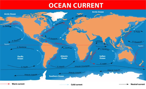
The ocean currents. Vector map
Ocean surface currents — Stock Vector
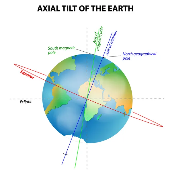
Axial tilt of the Earth. Vector diagram
Axial tilt of the Earth — Stock Vector
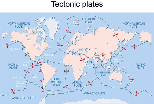
Map of Earth's principal tectonic plates. Earth's lithosphere. Major and minor plates. arrows indicate direction of movement at plate boundaries. Vector illustration
Map Earth Principal Tectonic Plates Earth Lithosphere Major Minor Plates — Stock Vector
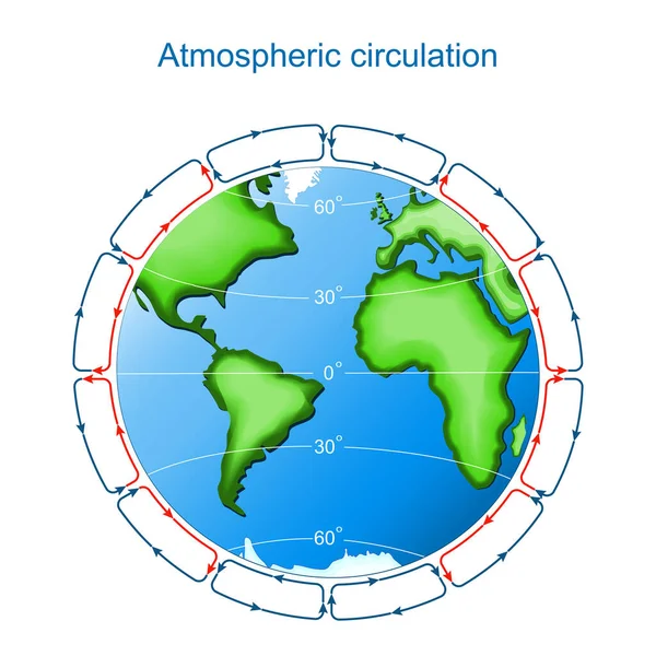
Circulation of Atmosphere. Global circulation patterns or Hadley-Ferrel Model
Circulation of Atmosphere — Stock Vector
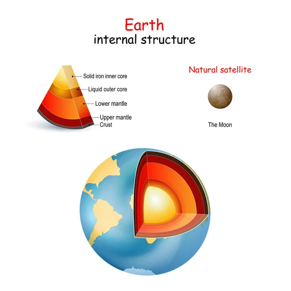
Earth internal structure. cross section of planets from core to mantle and crust. The Moon is only natural satellite. Solar system. Interior of Terrestrial. vector. Easy to edit
Earth Internal Structure Cross Section Planets Core Mantle Crust Moon — Stock Vector
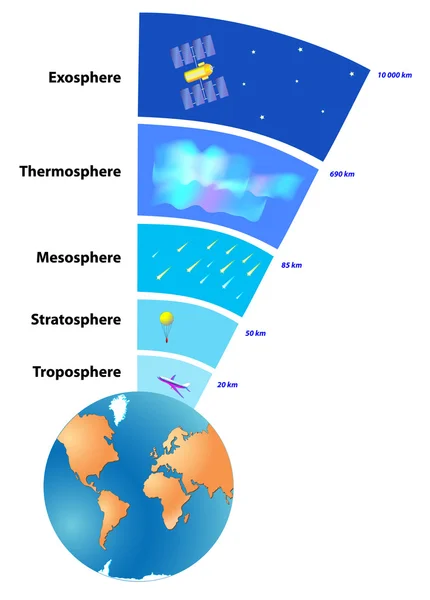
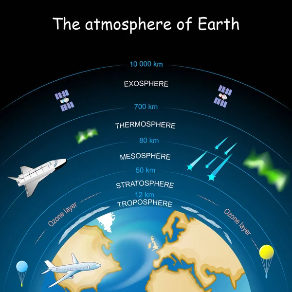
The atmosphere of Earth is a layer of gases surrounding the planet Earth that is retained by Earth's gravity. Vector
Atmosphere of Earth — Stock Vector
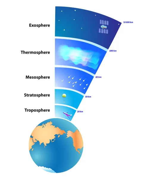
Atmosphere of Earth. Exosphere, Thermosphere, Mesosphere, Stratosphere, Troposphere. The atmosphere protects life on Earth.
Earth's atmosphere Layers — Stock Photo, Image
Atmosphere of Earth. layers of the atmosphere. Vector diagram. Poster for school education.
Atmosphere Earth Layers Atmosphere Vector Diagram Poster School Education — Stock Vector
Earth's magnetic field. Earth Planet with magnet, geographic and geomagnetic poles. Vector diagram
Earth Magnetic Field Earth Planet Magnet Geographic Geomagnetic Poles Vector — Stock Vector
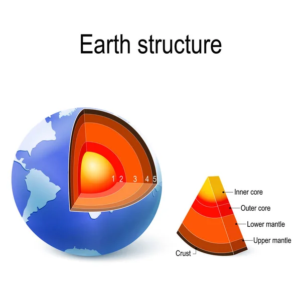
Earth. internal structure, cross section, and layers of the planet. Crust, upper mantle, lower mantle, outer core and inner core. vector illustration for education and science use.
Earth Internal Structure Cross Section Layers Planet Crust Upper Mantle — Stock Vector
Earth's magnetic (geomagnetic) field. The magnetosphere shields the surface of the Earth from the charged particles of the solar wind and is generated by electric currents located in different parts of the Earth. Vector diagram for educational, and s
Earth Magnetic Geomagnetic Field Magnetosphere Shields Surface Earth Charged Particles — Stock Vector
Atmospheric circulation on Earth. surface winds on planet. Circulation of Atmosphere. Global circulation patterns or Hadley-Ferrel Model. Vector illustration
Atmospheric Circulation Earth Surface Winds Planet Circulation Atmosphere Global Circulation — Stock Vector
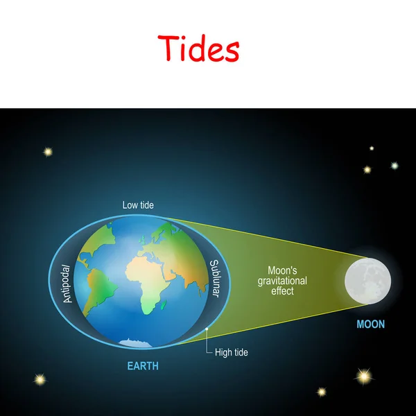
Tides diagram. Low and high lunar tides. Effect of Moon gravitational force on seacoast water level. vector illustration for astronomy, geography, educational and science for kids.
Tides Diagram Low High Lunar Tides Effect Moon Gravitational Force — Stock Vector

Similar Stock Videos:

Soft colors of mountains and forests. Map of New York. Zoom from a world map to a map of New York. 4K FHD 60 fps animation.
Soft colors of mountains and forests. Map of New York. World map. Map of the USA. Zoom from a world map to a map of New York. Zoom from USA map to New York map. 4K FHD 60 fps animation. — Stock Video
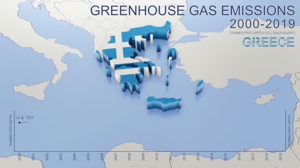
Greenhouse gas emissions in Greece from 2000 to 2019. Values in tonnes per capita (CO2 equivalent). Source data: Eurostat. 3D rendering loop able video with 4K resolution.
Greenhouse Gas Emissions Greece 2000 2019 Values Tonnes Capita Co2 — Stock Video
An animation of India map with coronavirus and Pray For India word. India been hit with terrible wave of coronavirus and worse around the world.
Animation India Map Coronavirus Pray India Word India Been Hit — Stock Video
The division of Europe and Asia on the map. the city Ekaterinburg divides Europe and Asia. Eurasia on the map Animation. Eurasia. Yekaterinburg animation HD
The division of Europe and Asia on the map. the city Ekaterinburg divides Europe and Asia. Eurasia on the map Animation. Eurasia. Yekaterinburg animation — Stock Video
Abstract line animation New York State of USA on hexagon style. New York state. United States of America. Outline map of New York federal state highlighted from map of USA.
Abstract line animation New York State of USA on hexagon style. New York state. United States of America. Outline map of New York federal state highlighted from map of USA — Stock Video
Wisconsin State of USA. Animated map of USA showing the state of Wisconsin. United States of America. Neumorphism minimal style.
Wisconsin State of USA. Animated map of USA showing the state of Wisconsin. United States of America. Neumorphism minimal style — Stock Video
Line animated map showing the state of California from the united state of america. Motion graphics
Line animated map showing the state of California from the united state of america. Motion graphics. — Stock Video
Belgium Map Showing Up Intro By Regions 4k animated Belgium map intro background with countries appearing and fading one by one and camera movement.
Belgium Map Showing Up Intro By Regions 4k animated Belgium map intro background with countries appearing and fading one by one and camera movement — Stock Video
3D animation simulating the Ebola Virus Spreading to Europe from the African outbreak countries
Ebola Virus Spreading to Europe — Stock Video
Line animated map showing the state of Thailand. 2d map of Thailand.
Line animated map showing the state of Thailand. 2d map of Thailand. 4k — Stock Video
Abstract line animation Tennessee State of USA on hexagon style. Tennessee state. United States of America. Outline map of Tennessee federal state highlighted from map of USA.
Abstract line animation Tennessee State of USA on hexagon style. Tennessee state. United States of America. Outline map of Tennessee federal state highlighted from map of USA — Stock Video
Line animated map showing the state of Italy from the united state of america. 2d map of Italy.
Line animated map showing the state of Italy from the united state of america. 2d map of Italy. 4k — Stock Video
Saudi Arabia Map Showing Up Intro By Regions 4k animated Russia map intro background with countries appearing and fading one by one and camera movement.
Saudi Arabia Map Showing Up Intro By Regions 4k animated Russia map intro background with countries appearing and fading one by one and camera movement — Stock Video
Greenhouse gas emissions in France from 2000 to 2019. Values in tonnes per capita (CO2 equivalent). Source data: Eurostat. 3D rendering loop able video with 4K resolution.
Greenhouse Gas Emissions France 2000 2019 Values Tonnes Capita Co2 — Stock Video
Canada map icon isolated on background. 4K Video motion graphic animation
Canada map icon isolated on background. 4K Video motion graphic animation. — Stock Video
Light blue map of China with cities, roads and railways on a dark blue background. 4K Animation with alpha channel
Light blue map of China with cities, roads and railways on a dark blue background. — Stock Video
Animation of the map of East Asia region
Animation of the map of East Asia — Stock Video
Line animated map showing the state of Mississippi from the united state of america. Motion graphics
Line animated map showing the state of Mississippi from the united state of america. Motion graphics. — Stock Video

Usage Information

You can use this royalty-free vector image "El nino phenomenon" for personal and commercial purposes according to the Standard or Extended License. The Standard License covers most use cases, including advertising, UI designs, and product packaging, and allows up to 500,000 print copies. The Extended License permits all use cases under the Standard License with unlimited print rights and allows you to use the downloaded vector files for merchandise, product resale, or free distribution.

This stock vector image is scalable to any size. You can buy and download it in high resolution up to 4887x4207. Upload Date: Dec 25, 2013